Backroads Journal
The Road to Steamboat Lake
Just itching to get away from the family gathering for a sanity break, we grabbed a couple of hours and followed a route written up in a local magazine west and north from Steamboat Springs, Colorado. County Road 129 leaves US40 about one mile west of Steamboat and follows the Elk River through some of the most scenic farm and pasture land we have ever driven through. The many side roads are tempting and the Elk River flows full and clear, just beckoning to the fisherman. The Aspen and Cottonwood lined riverbanks frame many a gorgeous vista across the valley. Take your time to drink it all in.
About eighteen miles up Route 129 you will see a sign announcing your arrival in Clark. The town of Clark consists of one multi-tasking business named, appropriately enough, The Clark Store. The Clark Store sells gas, groceries and liquor. It’s a general store, post office and ice cream shop. If you want a great bottle of wine, you’ll be sure to find what you are looking for there. The store has a little bit of everything. Just sitting back reflecting on the memory, I could picture a quiet picnic along the Elk River, a great bottle of wine and a Rocky Road ice cream dessert from the Clark Store to top it off. Leaving the store, one of the local residents suggested an alternate route up to Steamboat Lake. A left just past the Clark Store and then the next right puts you on a fairly decent gravel road, CR64. This winding scenic road takes you through some picturesque ranchland, scattered Aspen groves and along the base of Sand Mountain. Take your time to enjoy the mountain views framed by the Aspen clearings.
At about 7 miles from Clark you begin getting glimpses of Steamboat Lake. Being a manmade reservoir, there are times of low water and lake is not beautiful in itself, but the surroundings make up for any lack of beauty. From the west side of the lake you can see Hahn’s Peak, just to the east, reflected in the cold, clear water with Mt. Zirkel and Mt. Ethel on either side, both in the 12,000 ft. range. Hahn’s Peak, topping out at 10,824 ft., is an almost perfect cone shaped and easy to pick out.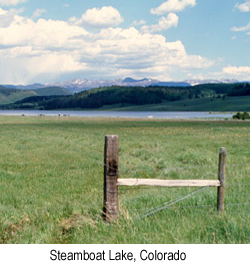 At 11.3 miles from Clark you will meet up with CR129 again. From here you can head north to the former mining town of Columbine or head south to explore the community of Hahn’s Peak, once a gold-mining town but now holding on to its past and its future by a thread. Take CR129 for 8 miles back south and you have the opportunity to explore the scenic Seedhouse Road. Our schedule did not allow us time to follow this pleasant drive, but by all means take it if you can. It runs for 12 miles up the Elk River through some of the most scenic area you will find. Watch for a small gorge where the Elk River has carved into the mountain. You’ll find it around the 6 mile mark. The road dead-ends at the trailhead for the Mt. Zirkel Wilderness Area, but the return trip allows you a new perspective on the beauty.
Back on CR129 and a half mile south puts you at the entrance to Home Ranch, a truly a one-of-a-kind, world class Ranch Resort. You can find information about this fantastic destination resort at www.homeranch.com. Running late for our family gathering at the Rio in Steamboat, we penciled in both the Seedhouse Road and Home Ranch as must-sees for our next trip out this way. It seems the more we explore, the longer our list of destinations seems to be!
Heading back down route 129, the long shadows across the rolling ranchlands etched some pretty peaceful memories in my mind and highlighted another fantastic scenic drive off the beaten path. We will return. The next time, I vow, we will have more time.